
Thornton Gap Entrance is Shenandoah National Parks most popular entrance because it is close to the best hikes, overlooks and the 2 SNP restaurants. Come for a drive! Enjoy the overlooks, take a hike, bring a picnic or enjoy lunch at Skyland Resort or Big Meadow lodge. Don't miss the famous Mile High Blackberry Ice Cream Pie, the gift shops, the SNP museum and the tour of the Summer White House. Some of our favorite hikes are Upper Hawksbill, Thornton River Trail, Stonyman, Little Devil Stairs, Mathews Arm, Mary’s Rock, Old Rag, White Oak Canyon, Dark Hollow Falls.

Shenandoah National Park amenities are open for the season April - November. SNP is in Little Washington Winery’s backyard! We're located in the foothills just below Skyline Drive's Milepost 31 at the Thornton Gap entrance.


(click image for Old Rag map)
You need a ticket to hike Old Rag
Old Rag - 9.2 miles - 2380 elevation - Very Strenuous - Enter this hike outside the Park - Old Rag is SNP’s most popular and dangerous hike. A day on Old Rag is one of Shenandoah's premier experiences. It has one of the most challenging rock scrambles in the park. The Loop is a 9 mile trail that will take you all day so plan to rise early. Go prepared with lunch and lots of water, not just a small water bottle. After you make it to the top, take the fire road down to make the whole thing a bit easier! Although Old Rag Mountain is within the boundaries of Shenandoah National Park, most people approach it from the park's eastern boundary. To get to the trailhead from Sperryville, Route 211: Take Route 522 south for .8 mile. Turn right onto Route 231 and go 8 miles. $10 parking if you don't have a Pass.

(click image for Devil Stairs map)
Devil Stairs - 5.6 miles - 1897 elevation - Strenuous - Enter this hike outside the park - Devil Stairs hike is one of the more scenic gorge hikes in SNP with two nice overlooks of the gorge and valley below. Little Devil Stairs, a 5.6-mile lasso loop scrambles upstream to waterfalls splashing in the deep gorge. Veer off-trail on Little Devil Stairs for stellar views like nothing else in Shenandoah. Park at the end of VA670/Keyser Run Road and parking area for Little Devils Stairs. ... Because of the steep grade the first two miles of the Little Devils Stairs hike can be tough if the day is warm. You'll work a little on the first two miles but it is worth it. There are numerous waterfalls along the run if the water levels are up. Bring extra socks and shoes for after the hike.

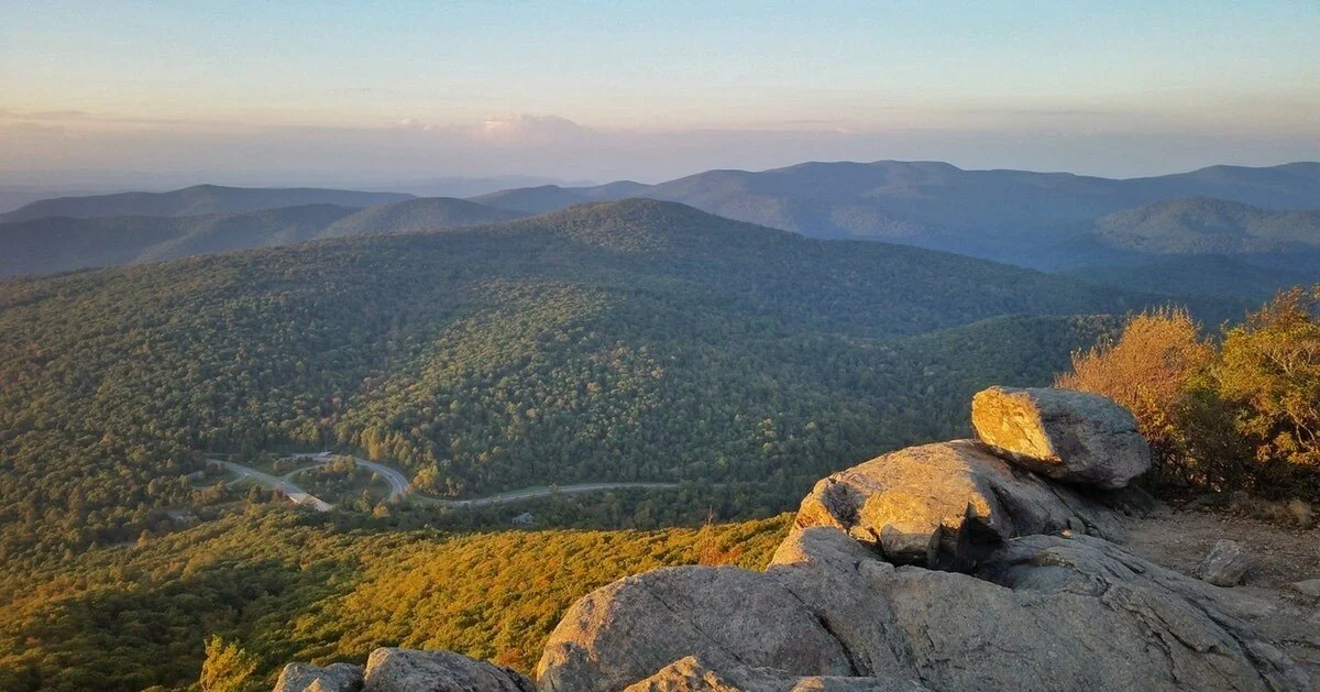
(click image for Mathews Arm map)
Milepost 22.2 - Mathews Arm Overall Run Falls 3.8 Miles - Moderate
A nice hike with the biggest falls in SNP at 93 feet. From the Mathews Arm Campground registration parking area at mile 22.2, take Traces Trail to the yellow-blazed Mathews Arm Road. The road becomes Mathews Arm Trail. Stay on the right at its intersection with Beecher Ridge Trail and continue on Mathews Arm Trail following it to the intersection with Tuscarora-Overall Run Trail. Go left and follow it about a tenth of a mile to a side trail. From here you can see the upper falls. Retrace your steps back to your starting point. NOTE: Unless rain is plentiful, Overall Run Falls may have minimal to no water flow.
(click image for Mary’s Rock map)
Milespost 31.6 - Mary's Rock - Easy
Mary's Rock summit is a fun, easy hike, and the view at the top is literally breathtaking. There are several ways to do this hike, depending on how far you want to walk. The prettiest and longest option is a half-day out and back 6.2-mile hike that starts from the Jewell Hollow Overlook parking lot and follows the AT almost to the summit. At the summit, there is plenty of space to relax and enjoy the view. Experienced hikers can catch the Buck Ridge trailhead from a parking lot right off Route 211, 2 miles west of Central Coffee Roasters. Buck Ridge adds 1,400 feet of elevation gain for a total elevation gain of 2,600 feet spread over 9 miles.

(click image for Skyland Resort map)
Milepost 41.6 - Skyland Resort
Skyland’s Dining Room serves wonderful regional specialties with farm-to-fork flavors and sumptuous views of the Shenandoah Valley. And considering the elevation of Skyland, it’s only natural that Mile-High Blackberry Ice Cream Pie is a house specialty! Decades before Shenandoah National Park was established, vacationers traveled to Skyland seeking respite from urbanized, mechanized city life. The resort was created in the late 1800s and grew in popularity among middle class business people in nearby urban areas.

(click image for Stony Man map)
Milepost 41.6 - Stony Man Trails - 1.6 miles - Easiest
Parking for the Stony Man hike is on milepost 41.6 of skyline drive. This trail covers Stony Man and Little Stony Man, both are worth seeing. This is a short, easy hike that will take you to some of the best views in Shenandoah National Park. It's an easy, 2.9 mile walk along the Appalachian Trail to the summit of Shenandoah's second highest peak. If you're looking to increase the level of difficulty, there is an alternate, moderate trail option that increases the mileage and leads to Little Stony Man Cliffs, just below the main peak, which is a popular rock wall with local climbers. Make sure to pick a haze free day, because you don't want to miss all the views along the the ridge!

(click image for White Oak Canyon map)
Milepost 42.6 - White Oak Canyon - 4.6 miles - moderate but long
This has to be the best waterfall hike in SNP with six waterfalls, cascading from 35 to 86 feet. There are swimming holes at the bottom of each waterfall, but do not expect much privacy because they are quite popular. The trailhead begins directly across Skyline Drive from Skyland Resort, making easy access to restaurants and facilities when you are finished hiking. The disclaimer is ... if you park there you will be walking down, down, down and then having to walk all the way back up to get to your vehicle after you have had a long, exhausting day. Don’t go all the way down. Be sure to bring your son so that you can say, "We quit. Please run as fast as you can to get the car before it gets dark!" Be sure to bring lunch, snacks and plenty of water.

(click image for Hawksbill map)
Milepost 45.5 - Hawksbill Loop - 2.9 miles - Moderate
Hawks Bill Summit is the highest point in Shenandoah National Park. A hike to the summit of Hawks Bill Mountain will not only put you at the highest point in Shenandoah National Park (4050'), but you'll have a 270 degree view perfect for a sunset. Best View we've Ever Seen. This is a quick 45 minute hike up. It is fairly easy but closer to the summit it gets very steep. Once you get to the summit there is a big boulder with 3 trails, make sure to take the one on the right- that has the best views. You can see 360 degrees, hear the falls below and see the Linville River. Absolutely beautiful and so fun to climb around the rocks on the summit. Don’t miss the extremely photogenic "Byrds Nest" is just 50' past the summit.

(click image on Dark Hollow Falls map)
Milepost 50.7 - Dark Hollow Falls
The 70-foot-tall Dark Hollow Falls, with 1,700+ reviews on AllTrails, is obviously a very popular hike. This hike can also be crowded. Pets are not allowed on this hike. When you go you’ll see why. It’s easily the most-visited hike of the Shenandoah National Park waterfalls, particularly given its proximity to Big Meadow lodge and mile high blackberry ice cream pie!

(click image for Big Meadow map)
Milepost 51 - Big Meadow
Big Meadow contains the park's Harry F. Byrd Visitor Center with a museum that walks you through the history of the building of SNP. Very interesting. Big Meadow is a great place for lunch and a cool place to wander. There’s no right or wrong way to do it; just follow the animals’ paths. Every season will reveal something special: wildflowers, fawns, butterflies, tracks in the snow—you never know what you might find. There are several hikes that start from here. Click the image for the area map. Campgrounds open beginning in spring, usually late March with Big Meadows opening first, followed by Lewis Mountain in April, and Mathews Arm and Dundo in May. Campgrounds begin closing in late fall.

(click image for Rapidan Camp map)
Summer White House - Rapidan Camp (Camp Hoover)
Built by U.S. President Herbert Hoover and his wife Lou Henry Hoover, Camp Hoover served as their rustic retreat throughout Hoover's administration from 1929 to 1933. The first family's residential cabin was known as the "Brown House" in contrast to their more famous residence, the White House. During the summer months, ranger-led tours of the camp are available, leaving from the Harry F. Byrd Visitor Center. Reservations are required and can be made by calling (877) 444-6777 or online at Recreation.gov Request the "Special Tours" category and specify Rapidan Camp. The tour features the president's cabin, The Brown House, which has been historically refurnished to its 1929 appearance.

(click image for Bear Fence map)
Milepost 56.4 - Bear Fence Mountain
Bear fence Mountain is a short, but deceptively challenging hike in the central district of Shenandoah National Park. Although it measures just 1.2 miles, it’s not for the faint of heart when it comes to heights. A photo taken from the correct location shows nothing but sky behind the person on the ledge. It has become a ritual to take photos of each other from this vantage point. If there are three or more in the party, the photo may show a second person on the close side of the outcropping stretching out a hand in a staged attempt to “save” the person who is pretending to be falling.

WELCOME TO THE MOST BEAUTIFUL ROAD IN AMERICA - SKYLINE DRIVE!
See that fat blue squiggly line running straight down the middle of the Virginia map? That’s one of Americas’ protected treasures, Shenandoah National Park (SNP).
65 miles west of Washington D.C. in the Blue Ridge mountains, Skyline Drive is the only road through Shenandoah National Park. It runs 105 miles along the Blue Ridge mountains. It takes about three hours to travel the entire length of SNP on a clear day.
There are 4 entrances - Front Royal (mile 0) | Thornton Gap (mile 31.5) | Swift Run Gap (mile 65.5) | Rockfish Gap (mile 104.6)
The best entrance is the Thornton Gap entrance (because that’s where all the amenities are). From Washington DC Take I-66 to the Gainesville/Warrenton exit 43A. Through Warrenton follow signs to Route 211, Sperryville and Shenandoah National Park. Click the map below for more detailed directions.


COUPON ~~ COUPON ~~ COUPON On your way back down from SNP stop by Little Washington Winery & Brewery and show us this coupon for a $5 Pint of beer or a glass of wine!

Little Washington Winery and Brewery After Hike Activity: When you hike Old Rag make sure to get a selfie on top of the summit. If you get down the mountain before 5pm pop over to Little Washington Winery in the same shirt with your selfie to show us you hiked it that same day. Wow - what an accomplishment - we'd like to buy you a beer or glass of wine!
From the deck at Little Washington Winery you can take another selfie of you and your glass of wine with the giant backdrop of Old Rag in the background for a cool memory of your hiking adventure!
